Introduction to GIS
Instructor: Matt Dunbar
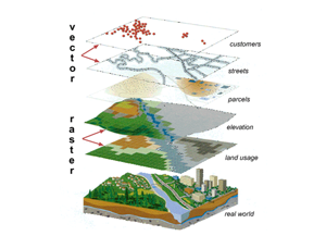
This workshop will begin by presenting an overview of the basic concepts of Spatial Analysis and Geographic Information Systems (GIS). Armed with an understanding of what GIS is, students will complete a hands-on tutorial introducing ESRI’s ArcGIS software. Topics covered during the first week’s lab will include: working with GIS data, simple data queries, and map creation (symbolization, labeling, layout and export). Building on the basic concepts covered during the first week, week 2 will focus entirely on hands-on training in GIS for demographic research. Topics covered in the second week’s lab will include: acquiring GIS and census data, synthesizing multiple data sources, and basic GIS analysis.
Prerequisites |
The workshop assumes no prior knowledge of GIS. |
Outline |
Part 1
Part 2
|
Materials |
Part 1 (Presentation, Exercise, and Data in .zip archive) Part 2 (Exercise in .zip archive) |
Additional Resources |
ArcGIS 10.X Desktop Help [Web] Data Resources
|